Latitude Longitude Readout
To enable readout in latitude longitude, make the currently active geographic coordinate system the active ACS. Select Tools -> Auxiliary Coordinates. Double click on the current geographic coordinate system to make it active.

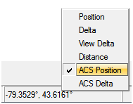
In the status bar where the running coordinates are located, LEFT-click and select ACS Position to start displaying latitude and longitude units.